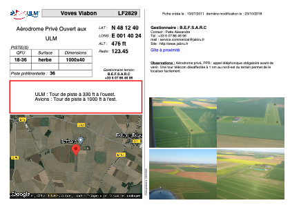
VAC chart of LF2829
 Satellite view of LF2829
Satellite view of LF2829
Sorry, we have no imagery here.
Sorry, we have no imagery here.
Sorry, we have no imagery here.
Sorry, we have no imagery here.
Sorry, we have no imagery here.
Sorry, we have no imagery here.


LF2829 - Voves Viabon
Located in Viabon, France
ICAO - , IATA -
Data provided by AirmateGeneral information
Coordinates: N48°12'40" E1°40'24"
Elevation is 476 feet MSL.
View others Airports in Centre
Operational data
Special qualification required
Current time UTC:
Current local time:
Weather at : LFOJ - Orleans Bricy ( 26 km )
METAR: LFOJ 100830Z AUTO 05013KT 8000 NSC 11/05 Q1027 NOSIG
TAF: TAF LFOJ 100800Z 1009/1109 04012KT CAVOK TX18/1015Z TN04/1106Z
Communications frequencies: [VIEW]
Runways:
| RWY identifier | QFU | Length (ft) | Width (ft) | Surface | LDA (ft) |
| 18 | 0° | 3280 | 131 | GRASS | |
| 36 | 0° | 3280 | 131 | GRASS |
Airport contact information
Address: Viabon France
Web: http://www.jabiru.fr
Satellite view of LF2829
Sorry, we have no imagery here.
Sorry, we have no imagery here.
Sorry, we have no imagery here.
Sorry, we have no imagery here.
Sorry, we have no imagery here.
Sorry, we have no imagery here.