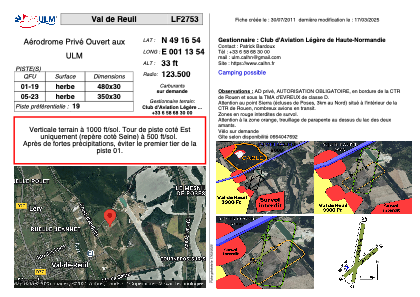
VAC chart of LF2753
 Satellite view of LF2753
Satellite view of LF2753
Sorry, we have no imagery here.
Sorry, we have no imagery here.
Sorry, we have no imagery here.
Sorry, we have no imagery here.
Sorry, we have no imagery here.
Sorry, we have no imagery here.


LF2753 - Val de Reuil
Located in Val-de-Reuil, France
ICAO - , IATA -
Data provided by AirmateGeneral information
Coordinates: N49°16'53" E1°13'53"
Elevation is 33 feet MSL.
View others Airports in Upper Normandy
Operational data
Special qualification required
Current time UTC:
Current local time:
Weather at : LFOP - Rouen Vallee De Seine ( 13 km )
METAR: LFOP 101430Z AUTO 04008KT 350V070 CAVOK 15/06 Q1027 NOSIG
TAF: TAF LFOP 101400Z 1015/1024 04008KT CAVOK
Communications frequencies: [VIEW]
Runways:
| RWY identifier | QFU | Length (ft) | Width (ft) | Surface | LDA (ft) |
| 01 | 0° | 1640 | 164 | GRASS | |
| 19 | 0° | 1640 | 164 | GRASS |
Airport contact information
Address: Val-de-Reuil France
Web: https://www.calhn.fr
Satellite view of LF2753
Sorry, we have no imagery here.
Sorry, we have no imagery here.
Sorry, we have no imagery here.
Sorry, we have no imagery here.
Sorry, we have no imagery here.
Sorry, we have no imagery here.