VAC chart of LF2721
 Satellite view of LF2721
Satellite view of LF2721
Sorry, we have no imagery here.
Sorry, we have no imagery here.
Sorry, we have no imagery here.
Sorry, we have no imagery here.
Sorry, we have no imagery here.
Sorry, we have no imagery here.


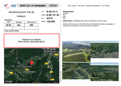
LF2721 - Saint Cyr La Campagne
Located in Saint-Cyr-la-Campagne, France
ICAO - , IATA -
Data provided by AirmateGeneral information
Coordinates: N49°15'11" E1°1'43"
Elevation is 370 feet MSL.
View others Airports in Upper Normandy
Operational data
Special qualification required
Current time UTC:
Current local time:
Weather at : LFOP - Rouen Vallee De Seine ( 19 km )
METAR: LFOP 152300Z AUTO 23007KT 9999 OVC042 08/04 Q1003
TAF: TAF LFOP 151400Z 1515/1524 18012KT 9999 BKN028 TEMPO 1515/1518 18015G25KT BECMG 1518/1520 25009KT
Communications frequencies: [VIEW]
Runways:
| RWY identifier | QFU | Length (ft) | Width (ft) | Surface | LDA (ft) |
| 04 | 0° | 1771 | 0 | ASPH | |
| 22 | 0° | 1771 | 0 | ASPH |
Airport contact information
Address: Saint-Cyr-la-Campagne France
Satellite view of LF2721
Sorry, we have no imagery here.
Sorry, we have no imagery here.
Sorry, we have no imagery here.
Sorry, we have no imagery here.
Sorry, we have no imagery here.
Sorry, we have no imagery here.