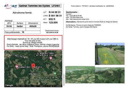
VAC chart of LF2461
 Satellite view of LF2461
Satellite view of LF2461
Sorry, we have no imagery here.
Sorry, we have no imagery here.
Sorry, we have no imagery here.
Sorry, we have no imagery here.
Sorry, we have no imagery here.
Sorry, we have no imagery here.


LF2461 - Galinat Tamnies les Eyzies
Located in Tamniès-Galinat , France
ICAO - , IATA -
Data provided by AirmateGeneral information
Coordinates: N44°59'31" E1°8'31"
Elevation is 655 feet MSL.
View others Airports in Aquitaine
Operational data
Special qualification required
Current time UTC:
Current local time:
Weather at : LFSL - Brive Souillac ( 28 km )
METAR: LFSL 022300Z AUTO 13011KT 100V160 CAVOK 11/03 Q1011
TAF: TAF AMD LFSL 021542Z 0215/0224 15010KT 9999 BKN040 TEMPO 0215/0220 VRB15G25KT 4000 SHRA FEW025CB BKN030TCU
Communications frequencies: [VIEW]
Runways:
Airport contact information
Address: Tamniès-Galinat France
Satellite view of LF2461
Sorry, we have no imagery here.
Sorry, we have no imagery here.
Sorry, we have no imagery here.
Sorry, we have no imagery here.
Sorry, we have no imagery here.
Sorry, we have no imagery here.