VAC chart of LF2351
 Satellite view of LF2351
Satellite view of LF2351
Sorry, we have no imagery here.
Sorry, we have no imagery here.
Sorry, we have no imagery here.
Sorry, we have no imagery here.
Sorry, we have no imagery here.
Sorry, we have no imagery here.


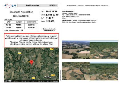
LF2351 - Le Pommier
Located in Saint-Maurice-la-Souterraine, France
ICAO - , IATA -
Data provided by AirmateGeneral information
Coordinates: N46°11'48" E1°27'10"
Elevation is 1140 feet MSL.
View others Airports in Centre
Operational data
Special qualification required
Current time UTC:
Current local time:
Weather at : LFBL - Limoges Bellegarde ( 43 km )
METAR: LFBL 101900Z AUTO 05012KT CAVOK 16/03 Q1021 NOSIG
TAF: TAF LFBL 101700Z 1018/1118 07012KT CAVOK BECMG 1100/1102 12006KT
Communications frequencies: [VIEW]
Runways:
| RWY identifier | QFU | Length (ft) | Width (ft) | Surface | LDA (ft) |
| 10 | 0° | 984 | 39 | GRASS | |
| 28 | 0° | 984 | 39 | GRASS |
Airport contact information
Address: Saint-Maurice-la-Souterraine France
Satellite view of LF2351
Sorry, we have no imagery here.
Sorry, we have no imagery here.
Sorry, we have no imagery here.
Sorry, we have no imagery here.
Sorry, we have no imagery here.
Sorry, we have no imagery here.