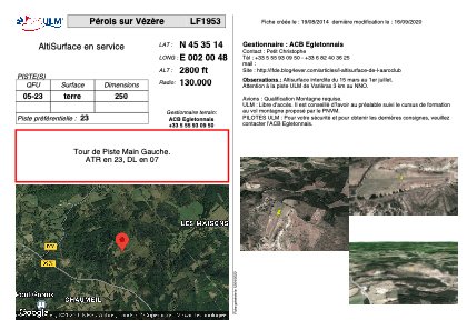
VAC chart of LF1953
 Satellite view of LF1953
Satellite view of LF1953
Sorry, we have no imagery here.
Sorry, we have no imagery here.
Sorry, we have no imagery here.
Sorry, we have no imagery here.
Sorry, we have no imagery here.
Sorry, we have no imagery here.


LF1953 - Pérols sur Vézère
Located in Pérols-sur-Vézère, France
ICAO - , IATA -
Data provided by AirmateGeneral information
Coordinates: N45°35'14" E2°0'48"
Elevation is 2800 feet MSL.
View others Airports in Limousin
Operational data
Special qualification required
Current time UTC:
Current local time:
Weather at : LFBL - Limoges Bellegarde ( 71 km )
METAR: LFBL 110630Z AUTO 07005KT CAVOK 12/03 Q1020 NOSIG
TAF: TAF LFBL 110500Z 1106/1206 08008KT CAVOK
Communications frequencies: [VIEW]
Runways:
| RWY identifier | QFU | Length (ft) | Width (ft) | Surface | LDA (ft) |
| 05 | 0° | 820 | 0 | DIRT | |
| 23 | 0° | 820 | 0 | DIRT |
Airport contact information
Address: Pérols-sur-Vézère France
Satellite view of LF1953
Sorry, we have no imagery here.
Sorry, we have no imagery here.
Sorry, we have no imagery here.
Sorry, we have no imagery here.
Sorry, we have no imagery here.
Sorry, we have no imagery here.