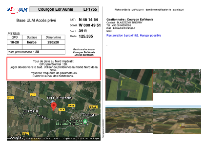
VAC chart of LF1755
 Satellite view of LF1755
Satellite view of LF1755
Sorry, we have no imagery here.
Sorry, we have no imagery here.
Sorry, we have no imagery here.
Sorry, we have no imagery here.
Sorry, we have no imagery here.
Sorry, we have no imagery here.


LF1755 - Courçon Eol'Aunis
Located in Courçon d'Aunis, France
ICAO - , IATA -
Data provided by AirmateGeneral information
Coordinates: N46°14'54" W0°49'51"
Elevation is 39 feet MSL.
View others Airports in Pays-de-la-Loire
Operational data
Special qualification required
Current time UTC:
Current local time:
Weather at : LFBH - La Rochelle Ile De Re ( 29 km )
TAF: TAF LFBH 070500Z 0706/0806 05008KT CAVOK TEMPO 0712/0719 32010KT
Communications frequencies: [VIEW]
Runways:
| RWY identifier | QFU | Length (ft) | Width (ft) | Surface | LDA (ft) |
| 10 | 0° | 951 | 65 | GRASS | |
| 28 | 0° | 951 | 65 | GRASS |
Airport contact information
Address: Courçon d'Aunis France
Satellite view of LF1755
Sorry, we have no imagery here.
Sorry, we have no imagery here.
Sorry, we have no imagery here.
Sorry, we have no imagery here.
Sorry, we have no imagery here.
Sorry, we have no imagery here.