VAC chart of LF1659
 Satellite view of LF1659
Satellite view of LF1659
Sorry, we have no imagery here.
Sorry, we have no imagery here.
Sorry, we have no imagery here.
Sorry, we have no imagery here.
Sorry, we have no imagery here.
Sorry, we have no imagery here.


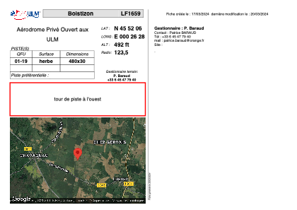
LF1659 - Boistizon
Located in Lussac, France
ICAO - , IATA -
Data provided by AirmateGeneral information
Coordinates: N45°52'6" E0°26'28"
Elevation is 492 feet MSL.
View others Airports in Poitou-Charentes
Operational data
Special qualification required
Current time UTC:
Current local time:
Weather at : LFBU - Angouleme Brie Champniers ( 23 km )
METAR: LFBU 070400Z AUTO 01007KT CAVOK 07/05 Q1017
TAF: TAF LFBU 061700Z 0618/0718 36010KT CAVOK PROB30 TEMPO 0700/0707 BKN008
Communications frequencies: [VIEW]
Runways:
| RWY identifier | QFU | Length (ft) | Width (ft) | Surface | LDA (ft) |
| 01 | 0° | 1574 | 98 | GRASS | |
| 19 | 0° | 1574 | 98 | GRASS |
Airport contact information
Address: Lussac France
Satellite view of LF1659
Sorry, we have no imagery here.
Sorry, we have no imagery here.
Sorry, we have no imagery here.
Sorry, we have no imagery here.
Sorry, we have no imagery here.
Sorry, we have no imagery here.