VAC chart of LF1652
 Satellite view of LF1652
Satellite view of LF1652
Sorry, we have no imagery here.
Sorry, we have no imagery here.
Sorry, we have no imagery here.
Sorry, we have no imagery here.
Sorry, we have no imagery here.
Sorry, we have no imagery here.


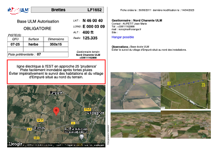
LF1652 - Brettes
Located in Villefagnan, France
ICAO - , IATA -
Data provided by AirmateGeneral information
Coordinates: N46°0'40" E0°3'9"
Elevation is 400 feet MSL.
View others Airports in Poitou-Charentes
Operational data
Special qualification required
Current time UTC:
Current local time:
Weather at : LFBU - Angouleme Brie Champniers ( 34 km )
METAR: LFBU 071730Z AUTO 01005KT CAVOK 20/04 Q1019 NOSIG
TAF: TAF LFBU 071700Z 0718/0818 35005KT CAVOK PROB30 TEMPO 0802/0806 3000 BR NSC
Communications frequencies: [VIEW]
Runways:
| RWY identifier | QFU | Length (ft) | Width (ft) | Surface | LDA (ft) |
| 07 | 0° | 1148 | 49 | GRASS | |
| 25 | 0° | 1148 | 49 | GRASS |
Airport contact information
Address: Villefagnan France
Satellite view of LF1652
Sorry, we have no imagery here.
Sorry, we have no imagery here.
Sorry, we have no imagery here.
Sorry, we have no imagery here.
Sorry, we have no imagery here.
Sorry, we have no imagery here.