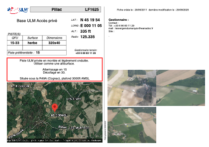
VAC chart of LF1625
 Satellite view of LF1625
Satellite view of LF1625
Sorry, we have no imagery here.
Sorry, we have no imagery here.
Sorry, we have no imagery here.
Sorry, we have no imagery here.
Sorry, we have no imagery here.
Sorry, we have no imagery here.


LF1625 - Pillac
Located in Pillac, France
ICAO - , IATA -
Data provided by AirmateGeneral information
Coordinates: N45°19'54" E0°11'5"
Elevation is 335 feet MSL.
View others Airports in Aquitaine
Operational data
Special qualification required
Current time UTC:
Current local time:
Weather at : LFBU - Angouleme Brie Champniers ( 44 km )
METAR: LFBU 022200Z AUTO 11009KT 070V150 CAVOK 11/05 Q1009
TAF: TAF LFBU 021700Z 0218/0318 12010KT 9999 BKN040 PROB30 TEMPO 0218/0220 12015G25KT 4000 SHRA FEW025CB BKN030TCU TEMPO 0302/0309 15015G25KT
Communications frequencies: [VIEW]
Runways:
| RWY identifier | QFU | Length (ft) | Width (ft) | Surface | LDA (ft) |
| 15 | 0° | 1049 | 131 | GRASS | |
| 33 | 0° | 1049 | 131 | GRASS |
Airport contact information
Address: Pillac France
Satellite view of LF1625
Sorry, we have no imagery here.
Sorry, we have no imagery here.
Sorry, we have no imagery here.
Sorry, we have no imagery here.
Sorry, we have no imagery here.
Sorry, we have no imagery here.