VAC chart of LF1456
 Satellite view of LF1456
Satellite view of LF1456
Sorry, we have no imagery here.
Sorry, we have no imagery here.
Sorry, we have no imagery here.
Sorry, we have no imagery here.
Sorry, we have no imagery here.
Sorry, we have no imagery here.


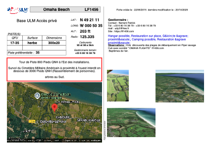
LF1456 - Omaha Beachh
Located in Colleville-sur-Mer, France
ICAO - , IATA -
Data provided by AirmateGeneral information
Coordinates: N49°21'11" W0°50'35"
Elevation is 203 feet MSL.
View others Airports in Lower Normandy
Operational data
Special qualification required
Current time UTC:
Current local time:
Weather at : LFRK - Caen Carpiquet ( 35 km )
METAR: LFRK 080200Z AUTO 00000KT 8000 NSC 05/03 Q1024
Communications frequencies: [VIEW]
Runways:
| RWY identifier | QFU | Length (ft) | Width (ft) | Surface | LDA (ft) |
| 17 | 0° | 984 | 65 | GRASS | |
| 35 | 0° | 984 | 65 | GRASS |
Airport contact information
Address: Colleville-sur-Mer France
Web: https://lf1456.com
Satellite view of LF1456
Sorry, we have no imagery here.
Sorry, we have no imagery here.
Sorry, we have no imagery here.
Sorry, we have no imagery here.
Sorry, we have no imagery here.
Sorry, we have no imagery here.