VAC chart of LF0354
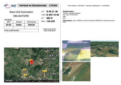 Satellite view of LF0354
Satellite view of LF0354
Sorry, we have no imagery here.
Sorry, we have no imagery here.
Sorry, we have no imagery here.
Sorry, we have no imagery here.
Sorry, we have no imagery here.
Sorry, we have no imagery here.


LF0354 - Verneuil en Bourbonnais
Located in Verneuil-en-Boubonnais, France
ICAO - , IATA -
Data provided by AirmateGeneral information
Coordinates: N46°21'36" E3°16'6"
Elevation is 885 feet MSL.
View others Airports in Auvergne
Operational data
Special qualification required
Current time UTC:
Current local time:
Weather at : LFLV - Vichy Charmeil ( 23 km )
METAR: LFLV 081200Z AUTO 03003KT 350V100 CAVOK 19/M00 Q1022
Communications frequencies: [VIEW]
Runways:
| RWY identifier | QFU | Length (ft) | Width (ft) | Surface | LDA (ft) |
| 02 | 0° | 820 | 65 | GRASS | |
| 20 | 0° | 820 | 65 | GRASS |
Airport contact information
Address: Verneuil-en-Boubonnais France
Satellite view of LF0354
Sorry, we have no imagery here.
Sorry, we have no imagery here.
Sorry, we have no imagery here.
Sorry, we have no imagery here.
Sorry, we have no imagery here.
Sorry, we have no imagery here.