VAC chart of LEVE
 Satellite view of LEVE
Satellite view of LEVE
Sorry, we have no imagery here.
Sorry, we have no imagery here.
Sorry, we have no imagery here.
Sorry, we have no imagery here.
Sorry, we have no imagery here.
Sorry, we have no imagery here.


LEVE - Virgen de la Estrella
Located in Los Santos de Maimona, Spain
ICAO - , IATA -
Data provided by AirmateGeneral information
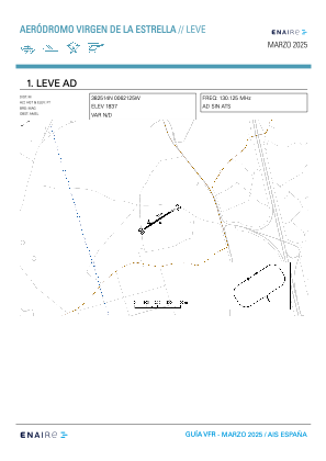
Coordinates: N38°25'14" W6°21'26"
Elevation is 1850 feet MSL.
Magnetic variation is -1° East View others Airports in Badajoz
Operational data
Special qualification required
Current time UTC:
Current local time:
Weather at : LEBZ - Badajoz/Talavera La Real ( 66 km )
METAR: LEBZ 100530Z 30004KT 270V330 CAVOK 17/13 Q1013
TAF: TAF LEBZ 100200Z 1003/1103 VRB03KT CAVOK TX25/1015Z TN13/1006Z TEMPO 1012/1017 11010KT
Communications frequencies: [VIEW]
Runways:
| RWY identifier | QFU | Length (ft) | Width (ft) | Surface | LDA (ft) |
| 06 | 56° | 939 | 43 | DIRT | |
| 24 | 236° | 939 | 43 | DIRT |
Airport contact information
Address: Los Santos de Maimona Spain
Satellite view of LEVE
Sorry, we have no imagery here.
Sorry, we have no imagery here.
Sorry, we have no imagery here.
Sorry, we have no imagery here.
Sorry, we have no imagery here.
Sorry, we have no imagery here.