VAC chart of LEUN
 Satellite view of LEUN
Satellite view of LEUN
Sorry, we have no imagery here.
Sorry, we have no imagery here.
Sorry, we have no imagery here.
Sorry, we have no imagery here.
Sorry, we have no imagery here.
Sorry, we have no imagery here.


LEUN - Calzada De Valdunciel
Located in Calzada de Valdunciel, Spain
ICAO - , IATA -
Data provided by AirmateGeneral information
Coordinates: N41°4'30" W5°43'40"
Elevation is 2664 feet MSL.
Magnetic variation is -1° East View others Airports in Salamanca
Operational data
Special qualification required
Current time UTC:
Current local time:
Weather at : LESA - Salamanca/Matacan ( 23 km )
METAR: LESA 092300Z AUTO VRB01KT CAVOK 10/07 Q1017
TAF: TAF LESA 092000Z 0921/1021 VRB04KT CAVOK TX24/1015Z TN07/1006Z PROB30 TEMPO 1004/1008 4000 BR BECMG 1012/1014 11010KT
Communications frequencies: [VIEW]
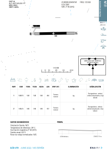
Runways:
| RWY identifier | QFU | Length (ft) | Width (ft) | Surface | LDA (ft) |
| 09 | 88° | 1893 | 60 | DIRT | |
| 27 | 268° | 1893 | 60 | DIRT |
Airport contact information
Address: Calzada de Valdunciel Spain
Satellite view of LEUN
Sorry, we have no imagery here.
Sorry, we have no imagery here.
Sorry, we have no imagery here.
Sorry, we have no imagery here.
Sorry, we have no imagery here.
Sorry, we have no imagery here.