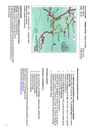
VAC chart of LECJSO
 Satellite view of LECJSO
Satellite view of LECJSO
Sorry, we have no imagery here.
Sorry, we have no imagery here.
Sorry, we have no imagery here.
Sorry, we have no imagery here.
Sorry, we have no imagery here.
Sorry, we have no imagery here.


LECJSO - Castejon de Sos
Located in Ch, Spain
ICAO - , IATA -
Data provided by AirmateGeneral information
Coordinates: N42°31'30" E0°28'48"
Elevation is 2970 feet MSL.
Magnetic variation is 1° East View others Airports in Huesca
Operational data
Special qualification required
Current time UTC:
Current local time:
Communications frequencies: [VIEW]
Runways:
| RWY identifier | QFU | Length (ft) | Width (ft) | Surface | LDA (ft) |
| 16 | 159° | 2014 | 50 | GRAS | |
| 34 | 339° | 2014 | 50 | GRAS |
Airport contact information
Address: Ch Spain
Other aviation service providers
Aviation club (not for profit)

Centro De Vuelo De Montaña De Castejón De Sos
Centro De Vuelo De Montaña De Castejón De Sos
angel.aviador@gmail.com+34689786087
+34689786087
+34689786087
Satellite view of LECJSO
Sorry, we have no imagery here.
Sorry, we have no imagery here.
Sorry, we have no imagery here.
Sorry, we have no imagery here.
Sorry, we have no imagery here.
Sorry, we have no imagery here.