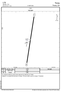
L72 - Trona
Located in Trona, United States
ICAO - L72, IATA -
Data provided by AirmateGeneral information
Coordinates: N35°48'46" W117°19'37"
Elevation is 1718 feet MSL.
Magnetic variation is 14° East View others Airports in California
Operational data
Special qualification required
Current time UTC:
Current local time:
Weather at : KNID - China Lake Naws (Armitage Fld) ( 36 km )
METAR: KNID 041856Z 34013G26KT 10SM SCT100 19/M08 A3011 RMK AO2 PK WND 32028/1836 SLP191 T01941083 $
TAF: TAF AMD KNID 0418/0515 36013G22KT 9999 FEW100 QNH3005INS WND 330V040 BECMG 0421/0423 12008KT 9999 SKC QNH2998INS WND 090V160 BECMG 0503/0505 30011KT 9999 SKC QNH3004INS BECMG 0513/0515 34013G22KT 9999 SKC QNH3015INS TX22/0421Z TN07/0514Z AMD 1820
Communications frequencies: [VIEW]
Runways:
| RWY identifier | QFU | Length (ft) | Width (ft) | Surface | LDA (ft) |
| 17 | 189° | 5910 | 60 | ASPH | |
| 35 | 9° | 5910 | 60 | ASPH |
Airport contact information
Address: Trona United States
Satellite view of L72
Sorry, we have no imagery here.
Sorry, we have no imagery here.
Sorry, we have no imagery here.
Sorry, we have no imagery here.
Sorry, we have no imagery here.
Sorry, we have no imagery here.


