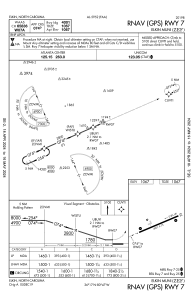
IAC chart of KZEF
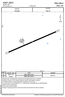
 ADC chart of KZEF
 Satellite view of KZEF
ADC chart of KZEF
Satellite view of KZEF
Sorry, we have no imagery here.
Sorry, we have no imagery here.
Sorry, we have no imagery here.
Sorry, we have no imagery here.
Sorry, we have no imagery here.
Sorry, we have no imagery here.


KZEF - Elkin Muni
Located in Elkin, United States
ICAO - ZEF, IATA -
Data provided by AirmateGeneral information
Coordinates: N36°16'48" W80°47'10"
Elevation is 1067 feet MSL.
Magnetic variation is -08° East View others Airports in North Carolina
Operational data
Special qualification required
Current time UTC:
Current local time:
Weather at : KUKF - Wilkes County ( 29 km )
METAR: KUKF 021335Z AUTO 00000KT 1 3/4SM DZ OVC004 07/07 A3032 RMK AO2 P0003
Communications frequencies: [VIEW]
Runways:
| RWY identifier | QFU | Length (ft) | Width (ft) | Surface | LDA (ft) |
| 07 | 67° | 4001 | 75 | ASPH | |
| 25 | 247° | 4001 | 75 | ASPH |
Airport contact information
Address: Elkin United States
Satellite view of KZEF
Sorry, we have no imagery here.
Sorry, we have no imagery here.
Sorry, we have no imagery here.
Sorry, we have no imagery here.
Sorry, we have no imagery here.
Sorry, we have no imagery here.