IAC chart of KWST
 ADC chart of KWST
 Satellite view of KWST
ADC chart of KWST
Satellite view of KWST
Sorry, we have no imagery here.
Sorry, we have no imagery here.
Sorry, we have no imagery here.
Sorry, we have no imagery here.
Sorry, we have no imagery here.
Sorry, we have no imagery here.


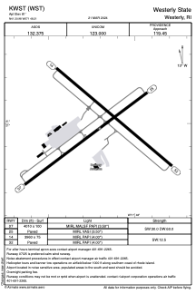
KWST - Westerly State
Located in Westerly, United States
ICAO - WST, IATA - WST
Data provided by AirmateGeneral information
Coordinates: N41°20'59" W71°48'12"
Elevation is 81 feet MSL.
Magnetic variation is -15° East View others Airports in Rhode Island
Operational data
Special qualification required
Current time UTC:
Current local time:
Weather
METAR: KWST 080453Z AUTO 35003KT 10SM OVC006 04/03 A2964 RMK AO2 CIG 005V009 PRESRR SLP036 T00390028 400940033
Communications frequencies: [VIEW]
Runways:
| RWY identifier | QFU | Length (ft) | Width (ft) | Surface | LDA (ft) |
| 07 | 53° | 4010 | 100 | ASPH | |
| 25 | 233° | 4010 | 100 | ASPH | |
| 14 | 130° | 3960 | 75 | ASPH | |
| 32 | 310° | 3960 | 75 | ASPH |
Airport contact information
Address: Westerly United States
Other aviation service providers
Flight schools

Satellite view of KWST
Sorry, we have no imagery here.
Sorry, we have no imagery here.
Sorry, we have no imagery here.
Sorry, we have no imagery here.
Sorry, we have no imagery here.
Sorry, we have no imagery here.