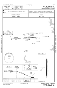
IAC chart of KWEA
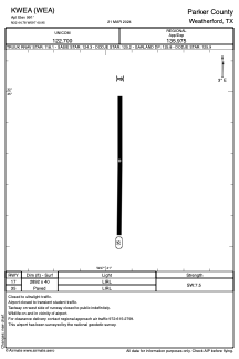
 ADC chart of KWEA
 Satellite view of KWEA
ADC chart of KWEA
Satellite view of KWEA
Sorry, we have no imagery here.
Sorry, we have no imagery here.
Sorry, we have no imagery here.
Sorry, we have no imagery here.
Sorry, we have no imagery here.
Sorry, we have no imagery here.


KWEA - Parker County
Located in Weatherford, United States
ICAO - WEA, IATA -
Data provided by AirmateGeneral information
Coordinates: N32°44'47" W97°40'57"
Elevation is 991 feet MSL.
Magnetic variation is 05° East View others Airports in Texas
Operational data
Special qualification required
Current time UTC:
Current local time:
Weather at : KNFW - Fort Worth Nas Jrb (Carswell Fld) ( 23 km )
METAR: KNFW 021152Z 18019G25KT 8SM OVC025 23/18 A2947 RMK AO2 PK WND 20031/1113 SLP966 T02330183 10233 20233 53008 $
TAF: TAF AMD KNFW 0210/0307 18018G30KT 9999 OVC025 QNH2942INS FM021200 19020G28KT 9999 VCTS OVC012CB QNH2949INS TEMPO 0212/0216 VRB25G40KT 1600 TSRA BKN008CB OVC016 FM021800 VRB06KT 9999 FEW025 FEW250 QNH2952INS TX30/0222Z TN17/0304Z AMD 1035 FN20046
Communications frequencies: [VIEW]
Runways:
| RWY identifier | QFU | Length (ft) | Width (ft) | Surface | LDA (ft) |
| 17 | 180° | 2892 | 40 | ASPH | |
| 35 | 0° | 2892 | 40 | ASPH |
Airport contact information
Address: Weatherford United States
Satellite view of KWEA
Sorry, we have no imagery here.
Sorry, we have no imagery here.
Sorry, we have no imagery here.
Sorry, we have no imagery here.
Sorry, we have no imagery here.
Sorry, we have no imagery here.