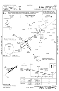
IAC chart of KWBW
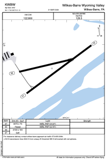
 ADC chart of KWBW
 Satellite view of KWBW
ADC chart of KWBW
Satellite view of KWBW
Sorry, we have no imagery here.
Sorry, we have no imagery here.
Sorry, we have no imagery here.
Sorry, we have no imagery here.
Sorry, we have no imagery here.
Sorry, we have no imagery here.


KWBW - Wilkes-Barre Wyoming Valley
Located in Wilkes-Barre, United States
ICAO - WBW, IATA - WBW
Data provided by AirmateGeneral information
Coordinates: N41°17'50" W75°51'8"
Elevation is 543 feet MSL.
Magnetic variation is -12° East View others Airports in Pennsylvania
Operational data
Special qualification required
Current time UTC:
Current local time:
Weather at : KAVP - Wilkes-Barre/Scranton Intl ( 12 km )
METAR: KAVP 081654Z 30012G36KT 10SM BKN055 OVC070 01/M09 A2974 RMK AO2 PK WND 32037/1557 SLP077 T00111094
TAF: KAVP 081120Z 0812/0912 29010G20KT P6SM SCT050 FM081500 30018G30KT P6SM SCT060 FM090000 30010G19KT P6SM SCT050
Communications frequencies: [VIEW]
Runways:
| RWY identifier | QFU | Length (ft) | Width (ft) | Surface | LDA (ft) |
| 07 | 54° | 3375 | 75 | ASPH | |
| 25 | 234° | 3375 | 75 | ASPH | |
| 09 | 77° | 2193 | 100 | OTHER | |
| 27 | 257° | 2193 | 100 | OTHER |
Airport contact information
Address: Wilkes-Barre United States
Other aviation service providers
Flight schools

Satellite view of KWBW
Sorry, we have no imagery here.
Sorry, we have no imagery here.
Sorry, we have no imagery here.
Sorry, we have no imagery here.
Sorry, we have no imagery here.
Sorry, we have no imagery here.