IAC chart of KWAY
 ADC chart of KWAY
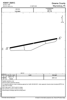
 Satellite view of KWAY
ADC chart of KWAY
Satellite view of KWAY
Sorry, we have no imagery here.
Sorry, we have no imagery here.
Sorry, we have no imagery here.
Sorry, we have no imagery here.
Sorry, we have no imagery here.
Sorry, we have no imagery here.


KWAY - Greene County
Located in Waynesburg, United States
ICAO - WAY, IATA - WAY
Data provided by AirmateGeneral information
Coordinates: N39°54'4" W80°7'50"
Elevation is 1068 feet MSL.
Magnetic variation is -09° East View others Airports in Pennsylvania
Operational data
Special qualification required
Current time UTC:
Current local time:
Weather at : KAFJ - Washington County ( 29 km )
METAR: KAFJ 081556Z AUTO 32010G21KT 10SM BKN041 00/M09 A3006 RMK AO2 UPB11E45SNE1458B13E25B29E30 SLP190 P0000 T00001089 FZRANO $
Communications frequencies: [VIEW]
Runways:
| RWY identifier | QFU | Length (ft) | Width (ft) | Surface | LDA (ft) |
| 09 | 0° | 3500 | 75 | ASPH | |
| 27 | 0° | 3500 | 75 | ASPH |
Airport contact information
Address: Waynesburg United States
Other aviation service providers
Flight schools

Satellite view of KWAY
Sorry, we have no imagery here.
Sorry, we have no imagery here.
Sorry, we have no imagery here.
Sorry, we have no imagery here.
Sorry, we have no imagery here.
Sorry, we have no imagery here.