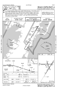
IAC chart of KWAL
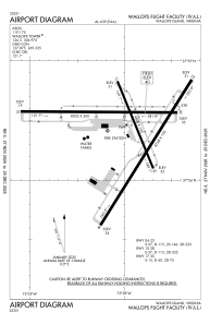
 ADC chart of KWAL
 Satellite view of KWAL
ADC chart of KWAL
Satellite view of KWAL
Sorry, we have no imagery here.
Sorry, we have no imagery here.
Sorry, we have no imagery here.
Sorry, we have no imagery here.
Sorry, we have no imagery here.
Sorry, we have no imagery here.


KWAL - Wallops Flight Facility
Located in Wallops Island, United States
ICAO - WAL, IATA - WAL
Data provided by AirmateGeneral information
Coordinates: N37°56'25" W75°27'59"
Elevation is 40 feet MSL.
Magnetic variation is -11° East View others Airports in Virginia
Operational data
Special qualification required
Current time UTC:
Current local time:
Weather
METAR: KWAL 011454Z 34013G23KT 10SM CLR 12/03 A2997 RMK AO2 SLP147 T01220028 53029
Communications frequencies: [VIEW]
Runways:
| RWY identifier | QFU | Length (ft) | Width (ft) | Surface | LDA (ft) |
| 04 | 32° | 8748 | 150 | OTHER | |
| 22 | 212° | 8748 | 150 | OTHER | |
| 10 | 90° | 8005 | 200 | OTHER | |
| 28 | 270° | 8005 | 200 | OTHER | |
| 17 | 158° | 4808 | 150 | ASPH | |
| 35 | 338° | 4808 | 150 | ASPH |
Airport contact information
Address: Wallops Island United States
Satellite view of KWAL
Sorry, we have no imagery here.
Sorry, we have no imagery here.
Sorry, we have no imagery here.
Sorry, we have no imagery here.
Sorry, we have no imagery here.
Sorry, we have no imagery here.