IAC chart of KVVS
 ADC chart of KVVS
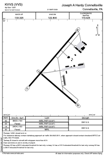
 Satellite view of KVVS
ADC chart of KVVS
Satellite view of KVVS
Sorry, we have no imagery here.
Sorry, we have no imagery here.
Sorry, we have no imagery here.
Sorry, we have no imagery here.
Sorry, we have no imagery here.
Sorry, we have no imagery here.


KVVS - Joseph A Hardy Connellsville
Located in Connellsville, United States
ICAO - VVS, IATA -
Data provided by AirmateGeneral information
Coordinates: N39°57'33" W79°39'27"
Elevation is 1264 feet MSL.
Magnetic variation is -08° East View others Airports in Pennsylvania
Operational data
Special qualification required
Current time UTC:
Current local time:
Weather at : KLBE - Arnold Palmer Rgnl ( 41 km )
METAR: KLBE 081145Z 30012KT 10SM -SN SCT042 SCT060 M03/M06 A2993
TAF: KLBE 081120Z 0812/0912 29009G16KT P6SM BKN035 TEMPO 0812/0814 6SM -SHSN BKN025 FM081500 29017G27KT P6SM BKN040 FM082300 31009G17KT P6SM SCT050 FM090300 00000KT P6SM FEW050
Communications frequencies: [VIEW]
Runways:
| RWY identifier | QFU | Length (ft) | Width (ft) | Surface | LDA (ft) |
| 05 | 41° | 3833 | 100 | ASPH | |
| 23 | 221° | 3833 | 100 | ASPH | |
| 14 | 131° | 2404 | 100 | ASPH | |
| 32 | 311° | 2404 | 100 | ASPH |
Airport contact information
Address: Connellsville United States
Satellite view of KVVS
Sorry, we have no imagery here.
Sorry, we have no imagery here.
Sorry, we have no imagery here.
Sorry, we have no imagery here.
Sorry, we have no imagery here.
Sorry, we have no imagery here.