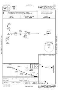
IAC chart of KVNW
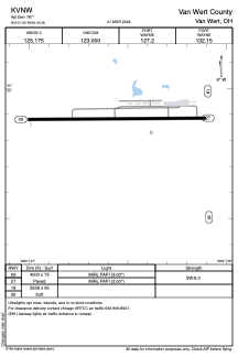
 ADC chart of KVNW
 Satellite view of KVNW
ADC chart of KVNW
Satellite view of KVNW
Sorry, we have no imagery here.
Sorry, we have no imagery here.
Sorry, we have no imagery here.
Sorry, we have no imagery here.
Sorry, we have no imagery here.
Sorry, we have no imagery here.


KVNW - Van Wert County
Located in Van Wert, United States
ICAO - VNW, IATA -
Data provided by AirmateGeneral information
Coordinates: N40°51'50" W84°36'23"
Elevation is 787 feet MSL.
Magnetic variation is -05° East View others Airports in Ohio
Operational data
Special qualification required
Current time UTC:
Current local time:
Weather at : KAXV - Neil Armstrong ( 49 km )
METAR: KAXV 081215Z AUTO 34009KT 10SM CLR M04/M10 A3011 RMK AO2
Communications frequencies: [VIEW]
Runways:
| RWY identifier | QFU | Length (ft) | Width (ft) | Surface | LDA (ft) |
| 09 | 90° | 4000 | 75 | ASPH | |
| 27 | 270° | 4000 | 75 | ASPH | |
| 18 | 179° | 2558 | 95 | GRASS | |
| 36 | 359° | 2558 | 95 | GRASS |
Airport contact information
Address: Van Wert United States
Other aviation service providers
Flight schools

Van Wert County Regional Airport Authority
Van Wert County Regional Airport Authority
vwariport@embarqmail.com+1(419)232-4500
Satellite view of KVNW
Sorry, we have no imagery here.
Sorry, we have no imagery here.
Sorry, we have no imagery here.
Sorry, we have no imagery here.
Sorry, we have no imagery here.
Sorry, we have no imagery here.