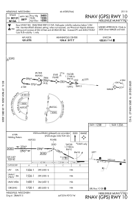
IAC chart of KVIQ
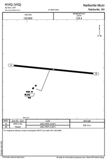
 ADC chart of KVIQ
 Satellite view of KVIQ
ADC chart of KVIQ
Satellite view of KVIQ
Sorry, we have no imagery here.
Sorry, we have no imagery here.
Sorry, we have no imagery here.
Sorry, we have no imagery here.
Sorry, we have no imagery here.
Sorry, we have no imagery here.


KVIQ - Neillsville Muni
Located in Neillsville, United States
ICAO - VIQ, IATA -
Data provided by AirmateGeneral information
Coordinates: N44°33'29" W90°30'44"
Elevation is 1237 feet MSL.
Magnetic variation is -01° East View others Airports in Wisconsin
Operational data
Special qualification required
Current time UTC:
Current local time:
Weather at : KMFI - Marshfield Muni ( 27 km )
METAR: KMFI 301854Z AUTO 31014G23KT 10SM OVC085 21/09 A2979 RMK AO2 PK WND 31026/1825 SLP087 T02110094
Communications frequencies: [VIEW]
Runways:
| RWY identifier | QFU | Length (ft) | Width (ft) | Surface | LDA (ft) |
| 10 | 96° | 3400 | 60 | ASPH | |
| 28 | 276° | 3400 | 60 | ASPH |
Airport contact information
Address: Neillsville United States
Satellite view of KVIQ
Sorry, we have no imagery here.
Sorry, we have no imagery here.
Sorry, we have no imagery here.
Sorry, we have no imagery here.
Sorry, we have no imagery here.
Sorry, we have no imagery here.