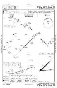
IAC chart of KVHN
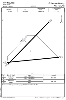
 ADC chart of KVHN
 Satellite view of KVHN
ADC chart of KVHN
Satellite view of KVHN
Sorry, we have no imagery here.
Sorry, we have no imagery here.
Sorry, we have no imagery here.
Sorry, we have no imagery here.
Sorry, we have no imagery here.
Sorry, we have no imagery here.


KVHN - Culberson County
Located in Van Horn, United States
ICAO - VHN, IATA -
Data provided by AirmateGeneral information
Coordinates: N31°3'28" W104°47'2"
Elevation is 3956 feet MSL.
Magnetic variation is 10° East View others Airports in Texas
Operational data
Special qualification required
Current time UTC:
Current local time:
Weather at : - ( 0 km )
METAR: SLTJ 021320Z 15004KT 9999 SCT005 SCT025 OVC040 13/11 Q1019
Communications frequencies: [VIEW]
Runways:
| RWY identifier | QFU | Length (ft) | Width (ft) | Surface | LDA (ft) |
| 03 | 45° | 6005 | 76 | ASPH | |
| 21 | 225° | 6005 | 76 | ASPH | |
| 07 | 84° | 5353 | 75 | ASPH | |
| 25 | 264° | 5353 | 75 | ASPH |
Airport contact information
Address: Van Horn United States
Satellite view of KVHN
Sorry, we have no imagery here.
Sorry, we have no imagery here.
Sorry, we have no imagery here.
Sorry, we have no imagery here.
Sorry, we have no imagery here.
Sorry, we have no imagery here.