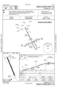
IAC chart of KUVA
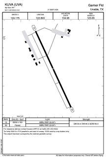
 ADC chart of KUVA
 Satellite view of KUVA
ADC chart of KUVA
Satellite view of KUVA
Sorry, we have no imagery here.
Sorry, we have no imagery here.
Sorry, we have no imagery here.
Sorry, we have no imagery here.
Sorry, we have no imagery here.
Sorry, we have no imagery here.


KUVA - Garner Fld
Located in Uvalde, United States
ICAO - UVA, IATA - UVA
Data provided by AirmateGeneral information
Coordinates: N29°12'41" W99°44'37"
Elevation is 941 feet MSL.
Magnetic variation is 07° East View others Airports in Texas
Operational data
Special qualification required
Current time UTC:
Current local time:
Weather
METAR: KUVA 021235Z AUTO 08006KT 7SM OVC013 23/23 A2956 RMK AO2 T02250225
Communications frequencies: [VIEW]
Runways:
| RWY identifier | QFU | Length (ft) | Width (ft) | Surface | LDA (ft) |
| 15 | 155° | 5256 | 100 | ASPH | |
| 33 | 335° | 5256 | 100 | ASPH |
Airport contact information
Address: Uvalde United States
Satellite view of KUVA
Sorry, we have no imagery here.
Sorry, we have no imagery here.
Sorry, we have no imagery here.
Sorry, we have no imagery here.
Sorry, we have no imagery here.
Sorry, we have no imagery here.