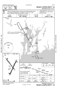
IAC chart of KUUU
 ADC chart of KUUU
 Satellite view of KUUU
ADC chart of KUUU
Satellite view of KUUU
Sorry, we have no imagery here.
Sorry, we have no imagery here.
Sorry, we have no imagery here.
Sorry, we have no imagery here.
Sorry, we have no imagery here.
Sorry, we have no imagery here.


KUUU - Newport State
Located in Newport, United States
ICAO - UUU, IATA - NPT
Data provided by AirmateGeneral information
Coordinates: N41°31'57" W71°16'54"
Elevation is 171 feet MSL.
Magnetic variation is -15° East View others Airports in Rhode Island
Operational data
Special qualification required
Current time UTC:
Current local time:
Weather
METAR: KUUU 081535Z AUTO VRB06KT 4SM RA BR FEW009 BKN016 OVC020 06/04 A2955 RMK AO2 RAB06 P0002 T00610039
Communications frequencies: [VIEW]
Runways:
| RWY identifier | QFU | Length (ft) | Width (ft) | Surface | LDA (ft) |
| 04 | 24° | 2999 | 75 | ASPH | |
| 22 | 204° | 2999 | 75 | ASPH | |
| 16 | 144° | 2623 | 75 | ASPH | |
| 34 | 324° | 2623 | 75 | ASPH |
Airport contact information
Address: Newport United States
Other aviation service providers
Flight schools

Satellite view of KUUU
Sorry, we have no imagery here.
Sorry, we have no imagery here.
Sorry, we have no imagery here.
Sorry, we have no imagery here.
Sorry, we have no imagery here.
Sorry, we have no imagery here.