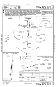
IAC chart of KUTS
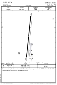
 ADC chart of KUTS
 Satellite view of KUTS
ADC chart of KUTS
Satellite view of KUTS
Sorry, we have no imagery here.
Sorry, we have no imagery here.
Sorry, we have no imagery here.
Sorry, we have no imagery here.
Sorry, we have no imagery here.
Sorry, we have no imagery here.


KUTS - Huntsville Muni
Located in Huntsville, United States
ICAO - UTS, IATA - HTV
Data provided by AirmateGeneral information
Coordinates: N30°44'49" W95°35'14"
Elevation is 362 feet MSL.
Magnetic variation is 06° East View others Airports in Texas
Operational data
Special qualification required
Current time UTC:
Current local time:
Weather
METAR: KUTS 021253Z AUTO 17012G27KT 10SM BKN022 24/21 A2962 RMK AO2 PK WND 18027/1213 SLP024 T02390206
TAF: KUTS 021231Z 0213/0312 17016G27KT P6SM BKN025 FM021800 18015G23KT P6SM SCT025 BKN050 FM030000 16010G20KT P6SM BKN015
Communications frequencies: [VIEW]
Runways:
| RWY identifier | QFU | Length (ft) | Width (ft) | Surface | LDA (ft) |
| 18 | 186° | 5005 | 100 | ASPH | |
| 36 | 6° | 5005 | 100 | ASPH |
Airport contact information
Address: Huntsville United States
Other aviation service providers
Flight schools

Satellite view of KUTS
Sorry, we have no imagery here.
Sorry, we have no imagery here.
Sorry, we have no imagery here.
Sorry, we have no imagery here.
Sorry, we have no imagery here.
Sorry, we have no imagery here.