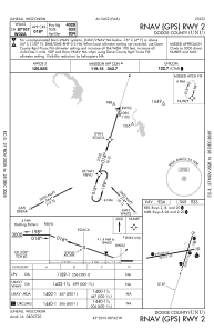
IAC chart of KUNU
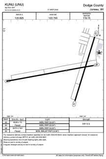
 ADC chart of KUNU
 Satellite view of KUNU
ADC chart of KUNU
Satellite view of KUNU
Sorry, we have no imagery here.
Sorry, we have no imagery here.
Sorry, we have no imagery here.
Sorry, we have no imagery here.
Sorry, we have no imagery here.


KUNU - Dodge County
Located in Juneau, United States
ICAO - UNU, IATA -
Data provided by AirmateGeneral information
Coordinates: N43°25'35" W88°42'14"
Elevation is 934 feet MSL.
Magnetic variation is -01° East View others Airports in Wisconsin
Operational data
Special qualification required
Current time UTC:
Current local time:
Weather
METAR: KUNU 300930Z AUTO 00000KT 10SM CLR 10/09 A2988 RMK AO2 T00990090 TSNO
Communications frequencies: [VIEW]
Runways:
| RWY identifier | QFU | Length (ft) | Width (ft) | Surface | LDA (ft) |
| 02 | 17° | 4028 | 75 | ASPH | |
| 20 | 197° | 4028 | 75 | ASPH | |
| 08 | 80° | 5070 | 100 | ASPH | |
| 26 | 260° | 5070 | 100 | ASPH |
Airport contact information
Address: Juneau United States
Other aviation service providers
Flight schools

Wisconsin Aviation-Dodge County
Wisconsin Aviation-Dodge County
Mary.Gasper@wisconsinaviation.com9203862402
Satellite view of KUNU
Sorry, we have no imagery here.
Sorry, we have no imagery here.
Sorry, we have no imagery here.
Sorry, we have no imagery here.
Sorry, we have no imagery here.