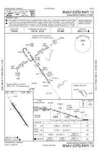
IAC chart of KUMP
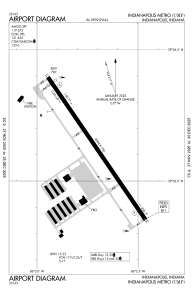
 ADC chart of KUMP
 Satellite view of KUMP
ADC chart of KUMP
Satellite view of KUMP
Sorry, we have no imagery here.
Sorry, we have no imagery here.
Sorry, we have no imagery here.
Sorry, we have no imagery here.
Sorry, we have no imagery here.
Sorry, we have no imagery here.


KUMP - Indianapolis Metro
Located in Indianapolis, United States
ICAO - UMP, IATA -
Data provided by AirmateGeneral information
Coordinates: N39°56'7" W86°2'42"
Elevation is 811 feet MSL.
Magnetic variation is -03° East View others Airports in Indiana
Operational data
Special qualification required
Current time UTC:
Current local time:
Weather at : KMQJ - Indianapolis Rgnl ( 16 km )
METAR: KMQJ 050915Z AUTO 17008KT 10SM OVC004 14/14 A2991 RMK AO2 RAE0914 P0000 T01400140 $
Communications frequencies: [VIEW]
Runways:
| RWY identifier | QFU | Length (ft) | Width (ft) | Surface | LDA (ft) |
| 15 | 146° | 4004 | 100 | ASPH | |
| 33 | 326° | 4004 | 100 | ASPH |
Airport contact information
Address: Indianapolis United States
Other aviation service providers
Repair station

Flight schools

Satellite view of KUMP
Sorry, we have no imagery here.
Sorry, we have no imagery here.
Sorry, we have no imagery here.
Sorry, we have no imagery here.
Sorry, we have no imagery here.
Sorry, we have no imagery here.