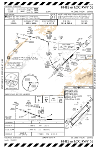
IAC chart of KTYS
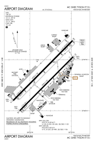
 ADC chart of KTYS
 Satellite view of KTYS
ADC chart of KTYS
Satellite view of KTYS
Sorry, we have no imagery here.
Sorry, we have no imagery here.
Sorry, we have no imagery here.
Sorry, we have no imagery here.
Sorry, we have no imagery here.
Sorry, we have no imagery here.


KTYS - Mc Ghee Tyson
Located in Knoxville, United States
ICAO - TYS, IATA - TYS
Data provided by AirmateGeneral information
Coordinates: N35°48'40" W83°59'39"
Elevation is 986 feet MSL.
Magnetic variation is -06° East View others Airports in Tennessee
Operational data
Special qualification required
Current time UTC:
Current local time:
Weather
METAR: KTYS 080853Z 28004KT 10SM FEW001 BKN070 07/05 A2989 RMK AO2 SLP120 T00670050 53003
TAF: KTYS 080520Z 0806/0906 23003KT P6SM FEW060 FM081600 36007KT P6SM SKC FM090300 05003KT P6SM SKC
Communications frequencies: [VIEW]
Runways:
| RWY identifier | QFU | Length (ft) | Width (ft) | Surface | LDA (ft) |
| 05L | 45° | 10000 | 150 | CONC | 9508 |
| 23R | 225° | 10000 | 150 | CONC | 9495 |
| 05R | 45° | 9000 | 150 | ASPH | 8600 |
| 23L | 225° | 9000 | 150 | ASPH | 8600 |
Airport contact information
Address: Knoxville United States
Satellite view of KTYS
Sorry, we have no imagery here.
Sorry, we have no imagery here.
Sorry, we have no imagery here.
Sorry, we have no imagery here.
Sorry, we have no imagery here.
Sorry, we have no imagery here.