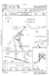
IAC chart of KTYR
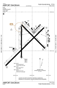
 ADC chart of KTYR
 Satellite view of KTYR
ADC chart of KTYR
Satellite view of KTYR
Sorry, we have no imagery here.
Sorry, we have no imagery here.
Sorry, we have no imagery here.
Sorry, we have no imagery here.
Sorry, we have no imagery here.
Sorry, we have no imagery here.


KTYR - Tyler Pounds Rgnl
Located in Tyler, United States
ICAO - TYR, IATA - TYR
Data provided by AirmateGeneral information
Coordinates: N32°21'13" W95°24'11"
Elevation is 544 feet MSL.
Magnetic variation is 03° East View others Airports in Texas
Operational data
Special qualification required
Current time UTC:
Current local time:
Weather
METAR: KTYR 020053Z 16013G21KT 4SM HZ OVC011 23/21 A2959 RMK AO2 SLP014 T02330206
TAF: KTYR 012338Z 0200/0224 16013G23KT P6SM VCTS OVC018CB FM020500 17019G24KT P6SM BKN030 FM020700 18018G23KT P6SM OVC015 FM021200 18018KT P6SM VCSH OVC015 FM021800 20015G22KT P6SM OVC015 FM022000 20011G18KT P6SM OVC050
Communications frequencies: [VIEW]
Runways:
| RWY identifier | QFU | Length (ft) | Width (ft) | Surface | LDA (ft) |
| 04 | 45° | 8334 | 150 | CONC | 7734 |
| 22 | 225° | 8334 | 150 | CONC | 7734 |
| 13 | 135° | 5198 | 150 | ASPH | 5198 |
| 31 | 315° | 5198 | 150 | ASPH | 5198 |
| 18 | 180° | 4832 | 150 | ASPH | 4832 |
| 36 | 0° | 4832 | 150 | ASPH | 4832 |
Airport contact information
Address: Tyler United States
Other aviation service providers
Flight schools

Satellite view of KTYR
Sorry, we have no imagery here.
Sorry, we have no imagery here.
Sorry, we have no imagery here.
Sorry, we have no imagery here.
Sorry, we have no imagery here.
Sorry, we have no imagery here.