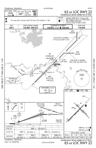
IAC chart of KTXK
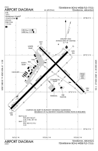
 ADC chart of KTXK
 Satellite view of KTXK
ADC chart of KTXK
Satellite view of KTXK
Sorry, we have no imagery here.
Sorry, we have no imagery here.
Sorry, we have no imagery here.
Sorry, we have no imagery here.
Sorry, we have no imagery here.
Sorry, we have no imagery here.


KTXK - Texarkana Rgnl-Webb Fld
Located in Texarkana, United States
ICAO - TXK, IATA - TXK
Data provided by AirmateGeneral information
Coordinates: N33°27'13" W93°59'28"
Elevation is 389 feet MSL.
Magnetic variation is 05° East View others Airports in Arkansas
Operational data
Special qualification required
Current time UTC:
Current local time:
Weather
METAR: KTXK 051209Z 10004KT 10SM -RA SCT049 BKN060 OVC075 21/20 A2979 RMK AO2 P0000 T02060200 $
TAF: KTXK 051120Z 0512/0612 08004KT P6SM SCT024 BKN035 OVC060 FM051400 04011G18KT 3SM TSRA OVC008CB FM052100 36011KT 2SM TSRA OVC007CB FM060100 01008G19KT 4SM -RA BR OVC007 FM060800 36006KT 4SM BR OVC003
Communications frequencies: [VIEW]
Runways:
| RWY identifier | QFU | Length (ft) | Width (ft) | Surface | LDA (ft) |
| 04 | 45° | 6602 | 150 | ASPH | 6602 |
| 22 | 225° | 6602 | 150 | ASPH | 6602 |
| 13 | 135° | 5200 | 100 | ASPH | 4559 |
| 31 | 315° | 5200 | 100 | ASPH | 4559 |
Airport contact information
Address: Texarkana United States
Other aviation service providers
Flight schools

Satellite view of KTXK
Sorry, we have no imagery here.
Sorry, we have no imagery here.
Sorry, we have no imagery here.
Sorry, we have no imagery here.
Sorry, we have no imagery here.
Sorry, we have no imagery here.