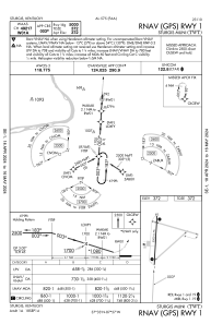
IAC chart of KTWT
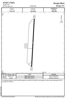
 ADC chart of KTWT
 Satellite view of KTWT
ADC chart of KTWT
Satellite view of KTWT
Sorry, we have no imagery here.
Sorry, we have no imagery here.
Sorry, we have no imagery here.
Sorry, we have no imagery here.
Sorry, we have no imagery here.
Sorry, we have no imagery here.


KTWT - Sturgis Muni
Located in Sturgis, United States
ICAO - TWT, IATA -
Data provided by AirmateGeneral information
Coordinates: N37°32'30" W87°57'16"
Elevation is 372 feet MSL.
Magnetic variation is 00° East View others Airports in Kentucky
Operational data
Special qualification required
Current time UTC:
Current local time:
Weather at : KEHR - Henderson City-County ( 38 km )
METAR: KEHR 021256Z AUTO 18014KT 10SM OVC035 19/14 A2969 RMK AO2 SLP053 T01940144
Communications frequencies: [VIEW]
Runways:
| RWY identifier | QFU | Length (ft) | Width (ft) | Surface | LDA (ft) |
| 01 | 3° | 5000 | 75 | ASPH | |
| 19 | 183° | 5000 | 75 | ASPH |
Airport contact information
Address: Sturgis United States
Satellite view of KTWT
Sorry, we have no imagery here.
Sorry, we have no imagery here.
Sorry, we have no imagery here.
Sorry, we have no imagery here.
Sorry, we have no imagery here.
Sorry, we have no imagery here.