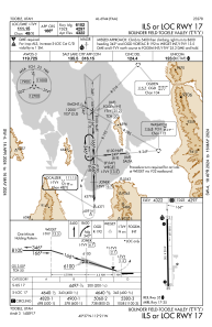
IAC chart of KTVY
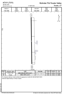
 ADC chart of KTVY
 Satellite view of KTVY
ADC chart of KTVY
Satellite view of KTVY
Sorry, we have no imagery here.
Sorry, we have no imagery here.
Sorry, we have no imagery here.
Sorry, we have no imagery here.
Sorry, we have no imagery here.
Sorry, we have no imagery here.


KTVY - Bolinder Fld/Tooele Valley
Located in Tooele, United States
ICAO - TVY, IATA -
Data provided by AirmateGeneral information
Coordinates: N40°36'45" W112°21'3"
Elevation is 4321 feet MSL.
Magnetic variation is 13° East View others Airports in Utah
Operational data
Special qualification required
Current time UTC:
Current local time:
Weather
METAR: KTVY 011615Z AUTO 32007KT 10SM SCT041 OVC050 03/M03 A2971 RMK AO2
Communications frequencies: [VIEW]
Runways:
| RWY identifier | QFU | Length (ft) | Width (ft) | Surface | LDA (ft) |
| 17 | 179° | 6102 | 100 | ASPH | 6102 |
| 35 | 359° | 6102 | 100 | ASPH | 5980 |
Airport contact information
Address: Tooele United States
Satellite view of KTVY
Sorry, we have no imagery here.
Sorry, we have no imagery here.
Sorry, we have no imagery here.
Sorry, we have no imagery here.
Sorry, we have no imagery here.
Sorry, we have no imagery here.