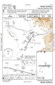
IAC chart of KTTD
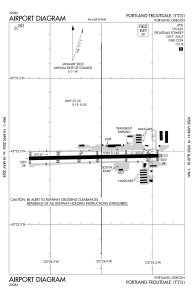
 ADC chart of KTTD
 Satellite view of KTTD
ADC chart of KTTD
Satellite view of KTTD
Sorry, we have no imagery here.
Sorry, we have no imagery here.
Sorry, we have no imagery here.
Sorry, we have no imagery here.
Sorry, we have no imagery here.
Sorry, we have no imagery here.


KTTD - Portland-Troutdale
Located in Portland, United States
ICAO - TTD, IATA -
Data provided by AirmateGeneral information
Coordinates: N45°32'58" W122°24'5"
Elevation is 38 feet MSL.
Magnetic variation is 16° East View others Airports in Oregon
Operational data
Special qualification required
Current time UTC:
Current local time:
Weather
METAR: KTTD 051353Z 09015G23KT 10SM CLR 10/00 A3029 RMK AO2 SLP256 T01000000
TAF: KTTD 051126Z 0512/0612 09015G25KT P6SM BKN250 FM060000 11007KT P6SM BKN100
Communications frequencies: [VIEW]
Runways:
| RWY identifier | QFU | Length (ft) | Width (ft) | Surface | LDA (ft) |
| 07 | 89° | 5399 | 150 | ASPH | |
| 25 | 269° | 5399 | 150 | ASPH | 5046 |
Airport contact information
Address: Portland United States
Other aviation service providers
Flight schools

Satellite view of KTTD
Sorry, we have no imagery here.
Sorry, we have no imagery here.
Sorry, we have no imagery here.
Sorry, we have no imagery here.
Sorry, we have no imagery here.
Sorry, we have no imagery here.