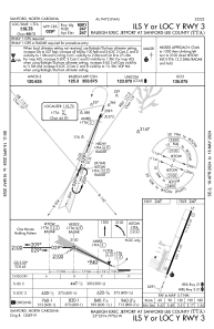
IAC chart of KTTA
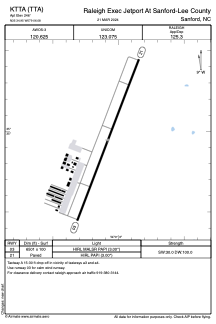
 ADC chart of KTTA
 Satellite view of KTTA
ADC chart of KTTA
Satellite view of KTTA
Sorry, we have no imagery here.
Sorry, we have no imagery here.
Sorry, we have no imagery here.
Sorry, we have no imagery here.
Sorry, we have no imagery here.
Sorry, we have no imagery here.


KTTA - Raleigh Exec Jetport At Sanford-Lee County
Located in Sanford, United States
ICAO - TTA, IATA -
Data provided by AirmateGeneral information
Coordinates: N35°34'57" W79°6'5"
Elevation is 246 feet MSL.
Magnetic variation is -08° East View others Airports in North Carolina
Operational data
Special qualification required
Current time UTC:
Current local time:
Weather
METAR: KTTA 020310Z AUTO 00000KT 10SM CLR 09/09 A3016 RMK AO2 T00860086
Communications frequencies: [VIEW]
Runways:
| RWY identifier | QFU | Length (ft) | Width (ft) | Surface | LDA (ft) |
| 03 | 21° | 6501 | 100 | ASPH | |
| 21 | 201° | 6501 | 100 | ASPH |
Airport contact information
Address: Sanford United States
Other aviation service providers
Flight schools

Executive Flight Training And Services, Llc
Executive Flight Training And Services, Llc
info@execft.com+1(919)986-9696
Satellite view of KTTA
Sorry, we have no imagery here.
Sorry, we have no imagery here.
Sorry, we have no imagery here.
Sorry, we have no imagery here.
Sorry, we have no imagery here.
Sorry, we have no imagery here.