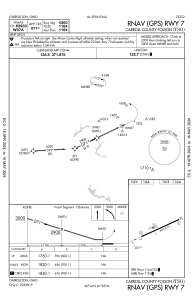
IAC chart of KTSO
 Satellite view of KTSO
Satellite view of KTSO
Sorry, we have no imagery here.
Sorry, we have no imagery here.
Sorry, we have no imagery here.
Sorry, we have no imagery here.
Sorry, we have no imagery here.
Sorry, we have no imagery here.


KTSO - Carroll County-Tolson
Located in Carrollton, United States
ICAO - TSO, IATA -
Data provided by AirmateGeneral information
Coordinates: N40°33'42" W81°4'41"
Elevation is 1163 feet MSL.
Magnetic variation is -07° East View others Airports in Ohio
Operational data
Special qualification required
Current time UTC:
Current local time:
Weather at : KPHD - Harry Clever Fld ( 31 km )
METAR: KPHD 081853Z AUTO 26007G17KT 220V320 10SM BKN048 03/M08 A3010 RMK AO2 SLP201 T00331078
Communications frequencies: [VIEW]
Runways:
| RWY identifier | QFU | Length (ft) | Width (ft) | Surface | LDA (ft) |
| 07 | 64° | 4300 | 75 | ASPH | |
| 25 | 244° | 4300 | 75 | ASPH |
Airport contact information
Address: Carrollton United States
Satellite view of KTSO
Sorry, we have no imagery here.
Sorry, we have no imagery here.
Sorry, we have no imagery here.
Sorry, we have no imagery here.
Sorry, we have no imagery here.
Sorry, we have no imagery here.