IAC chart of KTRI
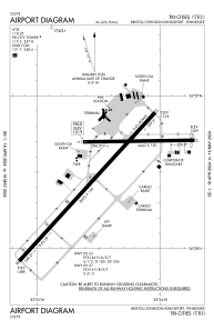
 ADC chart of KTRI
 Satellite view of KTRI
ADC chart of KTRI
Satellite view of KTRI
Sorry, we have no imagery here.
Sorry, we have no imagery here.
Sorry, we have no imagery here.
Sorry, we have no imagery here.
Sorry, we have no imagery here.
Sorry, we have no imagery here.


KTRI - Tri-Cities
Located in Bristol/Johnson/Kingsport, United States
ICAO - TRI, IATA - TRI
Data provided by AirmateGeneral information
Coordinates: N36°28'31" W82°24'27"
Elevation is 1518 feet MSL.
Magnetic variation is -07° East View others Airports in Tennessee
Operational data
Special qualification required
Current time UTC:
Current local time:
Weather
METAR: KTRI 081853Z 30009G20KT 10SM SCT050 SCT060 10/M04 A3001 RMK AO2 SLP155 T01001044
TAF: KTRI 081720Z 0818/0918 29007KT P6SM FEW045 FM090000 VRB03KT P6SM SCT250
Communications frequencies: [VIEW]
Runways:
| RWY identifier | QFU | Length (ft) | Width (ft) | Surface | LDA (ft) |
| 05 | 43° | 8000 | 150 | ASPH | 8000 |
| 23 | 223° | 8000 | 150 | ASPH | 8000 |
| 09 | 89° | 4443 | 150 | ASPH | 4321 |
| 27 | 269° | 4443 | 150 | ASPH | 4057 |
Airport contact information
Address: Bristol/Johnson/Kingsport United States
Other aviation service providers
Flight schools

Satellite view of KTRI
Sorry, we have no imagery here.
Sorry, we have no imagery here.
Sorry, we have no imagery here.
Sorry, we have no imagery here.
Sorry, we have no imagery here.
Sorry, we have no imagery here.