IAC chart of KTOI
 ADC chart of KTOI
 Satellite view of KTOI
ADC chart of KTOI
Satellite view of KTOI
Sorry, we have no imagery here.
Sorry, we have no imagery here.
Sorry, we have no imagery here.
Sorry, we have no imagery here.
Sorry, we have no imagery here.
Sorry, we have no imagery here.


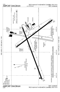
KTOI - Troy Muni At N Kenneth Campbell Fld
Located in Troy, United States
ICAO - TOI, IATA -
Data provided by AirmateGeneral information
Coordinates: N31°51'36" W86°0'50"
Elevation is 397 feet MSL.
Magnetic variation is -04° East View others Airports in Alabama
Operational data
Special qualification required
Current time UTC:
Current local time:
Weather
METAR: KTOI 050453Z AUTO 18004KT 10SM CLR 22/19 A3015 RMK AO2 SLP204 T02170189
Communications frequencies: [VIEW]
Runways:
| RWY identifier | QFU | Length (ft) | Width (ft) | Surface | LDA (ft) |
| 07 | 69° | 6197 | 100 | ASPH | |
| 25 | 250° | 6197 | 100 | ASPH | |
| 14 | 143° | 5024 | 100 | ASPH | |
| 32 | 323° | 5024 | 100 | ASPH |
Airport contact information
Address: Troy United States
Other aviation service providers
Flight schools

Satellite view of KTOI
Sorry, we have no imagery here.
Sorry, we have no imagery here.
Sorry, we have no imagery here.
Sorry, we have no imagery here.
Sorry, we have no imagery here.
Sorry, we have no imagery here.