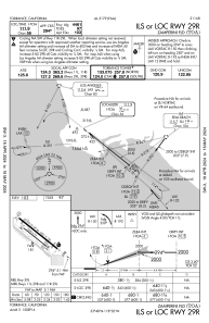
IAC chart of KTOA
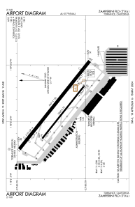
ADC chart of KTOA
Satellite view of KTOA
Sorry, we have no imagery here.
image banner adimage banner adimage banner ad
image banner ad

KTOA - Zamperini Fld

Located in Torrance, United States

ICAO - TOA, IATA -

Data provided by Airmate  

General information

Coordinates: N33°48'12" W118°20'23"
Elevation is 103 feet MSL.
Magnetic variation is 14° East
View others Airports in California

Operational data

Special qualification required
Current time UTC:
Current local time:
View NOTAMs / SUP AIP / TFR affecting this airport [VIEW]
Communications frequencies: [VIEW]

Runways:

RWY identifierQFULength (ft)Width (ft)SurfaceLDA (ft)
11L128°5001150OTHER
29R308°5001150OTHER
11R128°300075OTHER
29L308°300075OTHER
H100UNK

Airport contact information

Address: Torrance United States
Other aviation service providers

Repair station

Robinson Helicopter Co.

Robinson Helicopter Co.

Flight schools

Rolling Hills Aviation, Inc.

Rolling Hills Aviation, Inc.
aqmd@msn.com3103750061

South Bay Aviation, Inc.

South Bay Aviation, Inc.

Jj Helicopters, Inc.

Jj Helicopters, Inc.
info@jjheli.com+1(310)257-8622

Advanced Flight

Advanced Flight
nfo@advflt.com+1(310)908-8812

Pacific Skies Aviation

Pacific Skies Aviation
info@pacificskies.com+1(888)579-6999

South Coast Aeronautics

South Coast Aeronautics

Sling Flying Club

Sling Flying Club
fly@flyingclub.aero+1(424)241-0491

King Air First Officer

King Air First Officer

Satellite view of KTOA


BESbswy