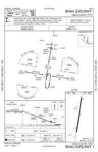
IAC chart of KTGC
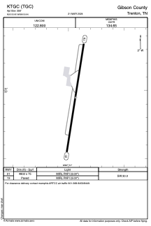
 ADC chart of KTGC
 Satellite view of KTGC
ADC chart of KTGC
Satellite view of KTGC
Sorry, we have no imagery here.
Sorry, we have no imagery here.
Sorry, we have no imagery here.
Sorry, we have no imagery here.
Sorry, we have no imagery here.
Sorry, we have no imagery here.


KTGC - Gibson County
Located in Trenton, United States
ICAO - TGC, IATA -
Data provided by AirmateGeneral information
Coordinates: N35°55'57" W88°50'56"
Elevation is 358 feet MSL.
Magnetic variation is -02° East View others Airports in Tennessee
Operational data
Special qualification required
Current time UTC:
Current local time:
Weather at : KMKL - Jackson Rgnl ( 37 km )
METAR: KMKL 062353Z AUTO 35012KT 7SM OVC006 08/07 A2992 RMK AO1 CIG 005V009 SLP132 6//// T00830072 10106 20083 50008 PNO $
TAF: KMKL 062325Z 0700/0724 35008KT 6SM BR OVC005 TEMPO 0710/0713 4SM BR OVC004 FM071500 35012KT P6SM OVC010 FM071800 36012G17KT P6SM BKN020 FM072100 34011KT P6SM SCT035
Communications frequencies: [VIEW]
Runways:
| RWY identifier | QFU | Length (ft) | Width (ft) | Surface | LDA (ft) |
| 01 | 9° | 4802 | 75 | ASPH | |
| 19 | 189° | 4802 | 75 | ASPH |
Airport contact information
Address: Trenton United States
Satellite view of KTGC
Sorry, we have no imagery here.
Sorry, we have no imagery here.
Sorry, we have no imagery here.
Sorry, we have no imagery here.
Sorry, we have no imagery here.
Sorry, we have no imagery here.