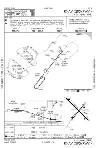
IAC chart of KTDZ
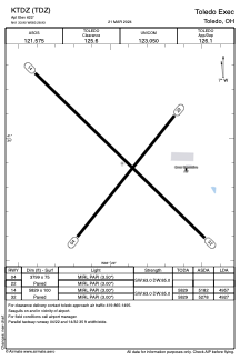
 ADC chart of KTDZ
 Satellite view of KTDZ
ADC chart of KTDZ
Satellite view of KTDZ
Sorry, we have no imagery here.
Sorry, we have no imagery here.
Sorry, we have no imagery here.
Sorry, we have no imagery here.
Sorry, we have no imagery here.
Sorry, we have no imagery here.


KTDZ - Toledo Exec
Located in Toledo, United States
ICAO - TDZ, IATA - TDZ
Data provided by AirmateGeneral information
Coordinates: N41°33'54" W83°28'56"
Elevation is 622 feet MSL.
Magnetic variation is -07° East View others Airports in Ohio
Operational data
Special qualification required
Current time UTC:
Current local time:
Weather
METAR: KTDZ 081453Z AUTO 31013G20KT 10SM CLR 00/M11 A3014 RMK AO2 SLP213 T00001111 51013
Communications frequencies: [VIEW]
Runways:
| RWY identifier | QFU | Length (ft) | Width (ft) | Surface | LDA (ft) |
| 04 | 39° | 3799 | 75 | ASPH | |
| 22 | 219° | 3799 | 75 | ASPH | |
| 14 | 134° | 5829 | 100 | ASPH | 4957 |
| 32 | 314° | 5829 | 100 | ASPH | 4927 |
Airport contact information
Address: Toledo United States
Satellite view of KTDZ
Sorry, we have no imagery here.
Sorry, we have no imagery here.
Sorry, we have no imagery here.
Sorry, we have no imagery here.
Sorry, we have no imagery here.
Sorry, we have no imagery here.