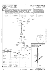
IAC chart of KTDW
 Satellite view of KTDW
Satellite view of KTDW
Sorry, we have no imagery here.
Sorry, we have no imagery here.
Sorry, we have no imagery here.
Sorry, we have no imagery here.
Sorry, we have no imagery here.
Sorry, we have no imagery here.


KTDW - Tradewind
Located in Amarillo, United States
ICAO - TDW, IATA - TDW
Data provided by AirmateGeneral information
Coordinates: N35°10'12" W101°49'33"
Elevation is 3648 feet MSL.
Magnetic variation is 08° East View others Airports in Texas
Operational data
Special qualification required
Current time UTC:
Current local time:
Weather at : KAMA - Rick Husband Amarillo Intl ( 12 km )
METAR: KAMA 021253Z 26013KT 10SM CLR 08/M10 A2961 RMK AO2 SLP991 T00781100 $
TAF: KAMA 021129Z 0212/0312 27015KT P6SM FEW170 FM021600 29016KT P6SM SKC FM022000 26014G22KT P6SM FEW230 FM030100 21011KT P6SM -SHRA SCT050 BKN100 FM031000 16012KT P6SM -SHRA OVC050
Communications frequencies: [VIEW]
Runways:
| RWY identifier | QFU | Length (ft) | Width (ft) | Surface | LDA (ft) |
| 05 | 56° | 3000 | 60 | ASPH | |
| 23 | 236° | 3000 | 60 | ASPH | |
| 17 | 180° | 5098 | 60 | ASPH | |
| 35 | 360° | 5098 | 60 | ASPH | |
| H1 | 0° | 0 | 0 | UNK |
Airport contact information
Address: Amarillo United States
Other aviation service providers
Flight schools

Satellite view of KTDW
Sorry, we have no imagery here.
Sorry, we have no imagery here.
Sorry, we have no imagery here.
Sorry, we have no imagery here.
Sorry, we have no imagery here.
Sorry, we have no imagery here.