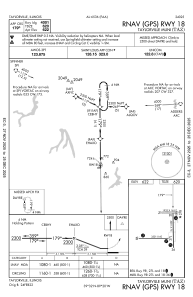
IAC chart of KTAZ
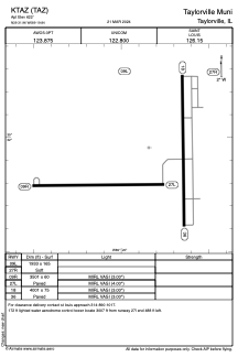
 ADC chart of KTAZ
 Satellite view of KTAZ
ADC chart of KTAZ
Satellite view of KTAZ
Sorry, we have no imagery here.
Sorry, we have no imagery here.
Sorry, we have no imagery here.
Sorry, we have no imagery here.
Sorry, we have no imagery here.
Sorry, we have no imagery here.


KTAZ - Taylorville Muni
Located in Taylorville, United States
ICAO - TAZ, IATA -
Data provided by AirmateGeneral information
Coordinates: N39°31'57" W89°19'51"
Elevation is 622 feet MSL.
Magnetic variation is 00° East View others Airports in Illinois
Operational data
Special qualification required
Current time UTC:
Current local time:
Weather
METAR: KTAZ 081339Z AUTO 10SM CLR 01/M04 A3024 RMK AO2
Communications frequencies: [VIEW]
Runways:
| RWY identifier | QFU | Length (ft) | Width (ft) | Surface | LDA (ft) |
| 09L | 90° | 1933 | 165 | GRASS | |
| 27R | 270° | 1933 | 165 | GRASS | |
| 09R | 90° | 3501 | 60 | ASPH | |
| 27L | 270° | 3501 | 60 | ASPH | |
| 18 | 179° | 4001 | 75 | ASPH | |
| 36 | 359° | 4001 | 75 | ASPH |
Airport contact information
Address: Taylorville United States
Satellite view of KTAZ
Sorry, we have no imagery here.
Sorry, we have no imagery here.
Sorry, we have no imagery here.
Sorry, we have no imagery here.
Sorry, we have no imagery here.
Sorry, we have no imagery here.