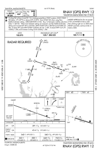
IAC chart of KTAN
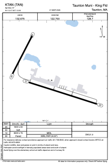
 ADC chart of KTAN
 Satellite view of KTAN
ADC chart of KTAN
Satellite view of KTAN
Sorry, we have no imagery here.
Sorry, we have no imagery here.
Sorry, we have no imagery here.
Sorry, we have no imagery here.
Sorry, we have no imagery here.
Sorry, we have no imagery here.


KTAN - Taunton Muni/King Fld
Located in Taunton, United States
ICAO - TAN, IATA -
Data provided by AirmateGeneral information
Coordinates: N41°52'27" W71°0'55"
Elevation is 41 feet MSL.
Magnetic variation is -16° East View others Airports in Massachusetts
Operational data
Special qualification required
Current time UTC:
Current local time:
Weather
METAR: KTAN 011352Z AUTO 32009G18KT FEW031 BKN085 BKN110 08/03 A2976 RMK AO2 RAE46 SLP076 P0001 T00830028 $
Communications frequencies: [VIEW]
Runways:
| RWY identifier | QFU | Length (ft) | Width (ft) | Surface | LDA (ft) |
| 04 | 27° | 1034 | 60 | OTHER | |
| 22 | 207° | 1034 | 60 | OTHER | |
| 12 | 108° | 3499 | 75 | ASPH | |
| 30 | 288° | 3499 | 75 | ASPH |
Airport contact information
Address: Taunton United States
Satellite view of KTAN
Sorry, we have no imagery here.
Sorry, we have no imagery here.
Sorry, we have no imagery here.
Sorry, we have no imagery here.
Sorry, we have no imagery here.
Sorry, we have no imagery here.