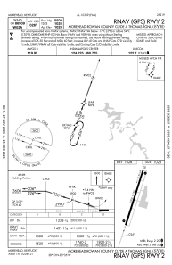
IAC chart of KSYM
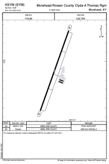
 ADC chart of KSYM
 Satellite view of KSYM
ADC chart of KSYM
Satellite view of KSYM
Sorry, we have no imagery here.
Sorry, we have no imagery here.
Sorry, we have no imagery here.
Sorry, we have no imagery here.
Sorry, we have no imagery here.
Sorry, we have no imagery here.


KSYM - Morehead-Rowan County Clyde A Thomas Rgnl
Located in Morehead, United States
ICAO - SYM, IATA -
Data provided by AirmateGeneral information
Coordinates: N38°12'54" W83°35'15"
Elevation is 1028 feet MSL.
Magnetic variation is -06° East View others Airports in Kentucky
Operational data
Special qualification required
Current time UTC:
Current local time:
Weather
METAR: KSYM 021315Z AUTO 17008G14KT 10SM FEW050 15/05 A2989 RMK AO2
TAF: KSYM 021139Z 0212/0312 15009KT P6SM FEW050 BKN090 WS020/19040KT FM021400 17011G33KT P6SM FEW050 SCT100 FM030300 19015G28KT P6SM BKN250 PROB30 0306/0307 4SM -TSRA BKN070CB FM030700 20014G32KT 6SM -SHRA SCT050 OVC070 PROB30 0307/0310 4SM TSRA BKN050CB FM031000 21012G29KT 6SM -SHRA SCT035 OVC045 PROB30 0310/0312 4SM TSRA BKN035CB
Communications frequencies: [VIEW]
Runways:
| RWY identifier | QFU | Length (ft) | Width (ft) | Surface | LDA (ft) |
| 02 | 20° | 5500 | 100 | ASPH | |
| 20 | 200° | 5500 | 100 | ASPH |
Airport contact information
Address: Morehead United States
Satellite view of KSYM
Sorry, we have no imagery here.
Sorry, we have no imagery here.
Sorry, we have no imagery here.
Sorry, we have no imagery here.
Sorry, we have no imagery here.
Sorry, we have no imagery here.