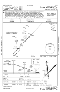
IAC chart of KSWW
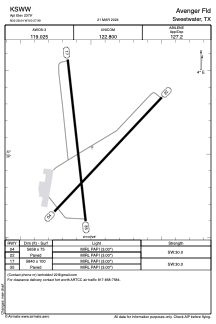
 ADC chart of KSWW
 Satellite view of KSWW
ADC chart of KSWW
Satellite view of KSWW
Sorry, we have no imagery here.
Sorry, we have no imagery here.
Sorry, we have no imagery here.
Sorry, we have no imagery here.
Sorry, we have no imagery here.
Sorry, we have no imagery here.


KSWW - Avenger Fld
Located in Sweetwater, United States
ICAO - SWW, IATA -
Data provided by AirmateGeneral information
Coordinates: N32°28'2" W100°27'60"
Elevation is 2379 feet MSL.
Magnetic variation is 08° East View others Airports in Texas
Operational data
Special qualification required
Current time UTC:
Current local time:
Weather
METAR: KSWW 012215Z AUTO 23018G29KT 10SM 32/06 A2949 RMK AO2 T03240055
Communications frequencies: [VIEW]
Runways:
| RWY identifier | QFU | Length (ft) | Width (ft) | Surface | LDA (ft) |
| 04 | 43° | 5658 | 75 | ASPH | |
| 22 | 223° | 5658 | 75 | ASPH | |
| 17 | 174° | 5840 | 100 | ASPH | |
| 35 | 354° | 5840 | 100 | ASPH |
Airport contact information
Address: Sweetwater United States
Satellite view of KSWW
Sorry, we have no imagery here.
Sorry, we have no imagery here.
Sorry, we have no imagery here.
Sorry, we have no imagery here.
Sorry, we have no imagery here.
Sorry, we have no imagery here.