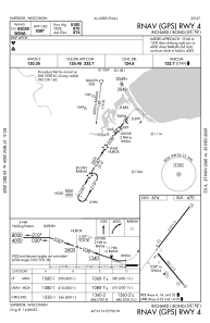
IAC chart of KSUW
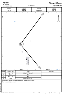
 ADC chart of KSUW
 Satellite view of KSUW
ADC chart of KSUW
Satellite view of KSUW
Sorry, we have no imagery here.
Sorry, we have no imagery here.
Sorry, we have no imagery here.
Sorry, we have no imagery here.
Sorry, we have no imagery here.
Sorry, we have no imagery here.


KSUW - Richard I Bong
Located in Superior, United States
ICAO - SUW, IATA -
Data provided by AirmateGeneral information
Coordinates: N46°41'23" W92°5'41"
Elevation is 674 feet MSL.
Magnetic variation is -01° East View others Airports in Wisconsin
Operational data
Special qualification required
Current time UTC:
Current local time:
Weather
METAR: KSUW 301755Z AUTO 30015G23KT 10SM CLR 25/09 A2979 RMK AO2 T02540090 10260 20164
Communications frequencies: [VIEW]
Runways:
| RWY identifier | QFU | Length (ft) | Width (ft) | Surface | LDA (ft) |
| 04 | 37° | 5100 | 75 | ASPH | |
| 22 | 217° | 5100 | 75 | ASPH | |
| 14 | 140° | 4001 | 75 | ASPH | |
| 32 | 320° | 4001 | 75 | ASPH |
Airport contact information
Address: Superior United States
Other aviation service providers
Flight schools

Superior Flying Services, Llc.
Superior Flying Services, Llc.
calvink@superiorflying.com+1(715)394-6444
Satellite view of KSUW
Sorry, we have no imagery here.
Sorry, we have no imagery here.
Sorry, we have no imagery here.
Sorry, we have no imagery here.
Sorry, we have no imagery here.
Sorry, we have no imagery here.